Omahu Bush to Hoon Hay Reserve 17 May 2023

                        Leader Mentor Understudy Tail Ender
Standards Chris H Jan B Cath L Judy R
Alternates Ali M Norma Brent McC Bill W

Stats: distance 14.7km, vertical ascent 260m, time 5 hrs

There were no weather worries today. With a high of 17 degrees forecast and a local tramp in the Port Hills, there was no doubt it would go ahead as planned.

With Judy R at the front of the bus on her first outing as President, 41 trampers including visitors Neil M, Maureen L-C, Mark and Megan T and Judy S, along with our driver Alan set off for our drop off point at the Omahu Bush car park on the Summit Road.

Although this tramp is a regular on the calendar, in previous years it has been done in reverse. The change enabled the bus to travel via Gebbies Pass and avoid a difficult turn around on the narrow Summit Road. There was however still a tense moment when encountering a van travelling in the opposite direction with no room for both vehicles to pass. The problem was solved when after a short discussion the van backed up to a wider part of the road with just enough room for both vehicles to get by.

Arriving at the car park, the 23 Standards set off on the grassy Prendergasts Track before cutting off into the bush. The Alternates would initially follow the same route but do a shorter loop in the bush rather than carrying on down to the waterfall.

Omahu Bush is the largest area of native bush close to Christchurch. In 1985 a covenant was signed to protect the bush, and in 1998 fencing was renewed to protect the area from damage caused by feral goats, pigs, deer and possums. There is a diverse range of native trees in the bush including mataī, lancewoods, tree fuchsias and kānuka with various ferns, including silver tree ferns under the canopy. The area is entered and exited by gates, and there are a few well maintained track options.

Walking along the pleasant bush track, bird song including bellbirds/ korimako could be heard in the upper branches, but it was the fantails that were happy to make themselves known. Although the track was well maintained, care was needed with some of the muddier sections.

The sound of rapidly flowing water meant our morning tea destination, Anne’s Falls was not too far away. Although some time was spent taking photos at the falls, it was very shady with not a lot of options for seating, so a spot further up the track in the sun was chosen instead. After tea it was decided to carry on in the sun rather than taking the possibly slippery track in the bush, so it was a long uphill slog on the grassy track to the Summit Road.

Crossing over after a short walk down the road the slippery track was again a bit of an issue and the merits of walking poles was discussed. Some of those without poles adopted more of a crawling position to clamber up the short uphill section to the track leading to Coopers Knob, the highest point on the Port Hills and our usual lunch spot. Thoughts of “at least there won’t be any wind this time” disappeared when a coolish wind sprung up just as the rocky outcrop was reached. The group then scattered with some selecting a spot higher up with more expansive views including Lyttelton Harbour, while others sat further down –  variously managing to escape the wind with views of Gibraltar Rock and the Canterbury Plains.

Leaving Coopers Knob and the wind behind us we backtracked five minutes to the undulating Crater Rim Track that would lead to the pickup point at Hoon Hay Reserve. With a mix of bush and open tussock, the track provided some great views of the calm waters of the harbour and a slightly hazy view of the plains with the snow sprinkled Alps in the background.

Arriving at the bus slightly later than expected the Alternates were already settled in having arrived over an hour earlier. Apart from a few minor slips and spills there were no major injuries in the group, although one member got a bit of unwanted attention from a bush lawyer that took a few minutes to resolve. With no time for a refreshment stop, the bus headed straight back to Bishopdale.

Text by Sally W
Lake Rubicon 10 May 2023

Leader Mentor Understudy Tail Ender
Standards Alan H Chris S Brent Ailsa
Alternates Bev & Nola & Ray & Norma & Eric Norma Ali Liz S

Stats: distance 12km approx, vertical ascent 400m, time 5 hrs approx

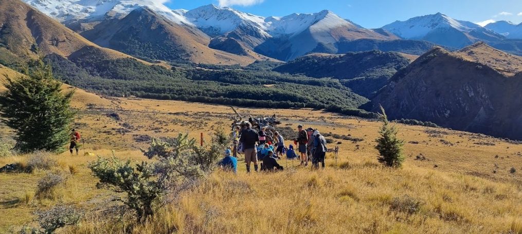
Many of us wondered if it was worthwhile getting our gear ready when the weather forecast was so bad for our Lake Rubicon tramp.  However there was just a little fog along the way, and nothing like the heavy rain or snow we had tossed and turned over.

After negotiating a little mud while we put on our packs near the Homestead at Brooksdale Station, all 41 of us set off happily up the first of … quite a few undulating hills. Through long grass, dodging cowpats and gigantic, flat thistles. Blue sky. Cold wind. The best thing was that the track was wide, and the topics of conversation were even wider. The usual: concerts, movies, and the merits (or not) of tramping naked, for example.

Morning tea was eaten standing up by some of the Standards because of the wet grass, and probably too by some of the 21 Alternates who arrived just as we were thinking about moving on. Up more hills, with the sun shining and the views rewarding us greatly for our efforts.

However, the bad news: the going (down) got really steep and difficult. Good news: our ‘route variations’ meant we had missed out on some nasty matagouri. Bad news: it had taken us longer than usual to get to this point. Best news ever: we could therefore lunch at the loveliest spot possible. This was just above a stunning river flat, with the luxury of sitting in the sun on the porch of the little hut we usually just passed by. There was even a clothes line for Peter M to hang his flash red merino-mink jersey on to make it toasty warm.

Then: past the wasp nest, er, back past the wasp nest, then heading back the right way, over the Rubicon stream (3 times). Best quip of the day heard, regarding our leader who tends to set off at an enthusiastically rapid pace, “Alan, I would follow you without fail into battle. Because by the time we actually caught up with you the whole war would be over!”

Wouldn’t it be boring if we set out on any given tramp, followed exactly the same route and arrived back at the bus at exactly the same time? Not going to happen, not on a farm foray like Lake Rubicon! There were the usual discussions about which side of the fence one should be on and which cattle track through the overgrown manuka looked slightly less impossible. Always fun. We emerged from the undergrowth to face one last steep hill, then to be greeted with the sights of (a) our Alternate buddies and (b) the celebrated Lake Rubicon below us. So, you might ask- where is the outflow for this quirky little lake? Underground, presumably (and don’t forget about the effects of evaporation). And then, you might also ask, what is the origin of the name Rubicon? A river in what is now northern Italy which Julius Caesar once famously led his troops across apparently. You may be surprised to learn that the great man never actually made it to this neck of the woods so it doesn’t really account for why we have a Rubicon in Canterbury.

So our joint army of 41 valiant foot soldiers marched along the narrow elevated path beside the lake, over the hillside of long wet tussocky grass, made our way across the wide dry riverbed, across verdant paddocks, and along the longest farm track ever, all the time chattering and nattering happily. We were even happier to reach the bus and get on board, and relax ready for the trip home. Almost everyone (but not all) had noticed slightly before this point that this was not actually the same bus we had boarded this morning. It was white, not purply-blue. There were no seatbelts and the seats were covered in an appalling patterned fabric. And our possessions were not necessarily in the same place as they had been on the first bus, which caused a few problems. Our trusty driver Alan, encountering technical difficulties with the front door of the bus just after we had started out on our tramp, had driven all the way back to town and returned with a very different bus.

Thanks Weather Team for not cancelling the tramp. It was great to get out, and our new club members Dave F and Cath L, and visitors Neil, Maureen L-C and Peter D seemed to have enjoyed themselves too. Just like Julius Caesar, we had ventured into slightly unknown territory, and conquered the mighty Rubicon.

Text by Shirley B

Camp Saddle and Helicopter Hill 26 April 2023

Leader Mentor Understudy Tail Ender
Standards Chris S Steve B Warren Veronica
Alternates Ray B Norma Ali Tessa

Stats: distance 13.4km, ascent 750m, time 5 hrs (approx.)

We woke to an overcast day and a question mark over the day’s tramp proceeding but it turned out to be another clear Camp Saddle and Helicopter Hill day. A big thank you was extended to the Weather Team for making the call to go ahead. We were 38 strong  (19 in each walking group) including visitors Peter D, Catherine L and Maureen L-C . Bus driver Viktor was warmly welcomed after an absence of some weeks.

This is a favourite tramp for many – it has something for everyone. It begins with a walk up the skifield road followed by a broad track through beech forest with korimako/bellbird song as an accompaniment. Reading previous trip reports, it has most often been fair weather walking. So it was on Wednesday. Coming out of the tree cover the cloud was breaking up offering glimpses of the Castle Hill Basin.

There was dew on the tussock as we wound our way up and across the slopes, making for soggy trouser bottoms. Some were beginning to describe the climb as “unrelenting” while our leader, who had mentioned that the family dog for the past five days had been taking him for daily runs, was bounding up the hill like a puppy fresh off a leash. Meanwhile the cloud continued to break tantalising us with the possibility of ever better views.

Camp Saddle provides that view. On this occasion it wasn’t a clear day when you can see forever – it was spectacular nonetheless. Looking up we could see the top of the Craigieburn skifield and ahead was the start of the rocky ridge we were to navigate after lunch.  It was chilly at the top. With extra layers on we started what can be the most challenging part of the walk. The track here is narrow and there are parts where the ridge is such that using hands for extra points of contact with the earth can feel like a good strategy. It’s exhilarating to have accomplished this part of the walk and chat turned to how alternate is not a noun in English (unless you’re speaking American English) however if Alternates became the Alternatives might there be an expectation that they be unorthodox?

Taking time to remove stones from boots at the bottom of the scree it was agreed that perhaps the hardest part of scree walking is at the top looking over the edge! There were people new to scree walking among us. Happily we’d all got down intact and seemed to have enjoyed it enough to want to come back and do it again. NB It was later revealed that someone who didn’t want to be named had taken a fall on the scree and in addition to a shin scrape had torn their favourite pear picking pants. Camp Saddle is a relatively long tramp and on our return walk tired legs lead to some cramping and several slips and stumbles. Fortunately none resulted in injury.

The Alternates’ walk also began on the skifield road then followed the Luge Track to Lyndon Saddle. Some stopped here for lunch while others continued up to the top of Helicopter Hill.  After lunch the group continued together via the Craigieburn Valley and Sidle 73 to return to Mistletoe Flat. This walk along the eastern and southern sides of Helicopter Hill completed the circuit. The Alternates had a wait of nearly two hours for the Standards to return.

Txt by Jen

Greta Valley 19 April 2023

Leader Mentor Understudy Tail Ender
Standards Peter Tony Brent Judy
Alternates Ali Bill W Gary G Bruce

 Distance: 14kms, elevation gain 504m, time 3hr 20min

 The members who were booked on the Greta Valley tramp and the Weather Team must have been anxious when heavy rain started falling on Tuesday evening. However, Wednesday morning dawned fine but heavily overcast and tramping was on much to everyone’s relief.

The 34 trampers including visitors David F, Cath L and guest Catherine L were joined by our North Canterbury contingent of two at Woodend. Driver Garry soon had us at Amberley for the usual stop before arriving at Greta Valley at 9.45am.

Numbers were fairly evenly split with 19 Standards and 17 Alternates. The tramp begins on the main road opposite the Greta Valley Tavern then winds its way through a farm track. This was a public walkway until about 10 years ago and the odd walkway sign remains. There is always a locked gate to negotiate but no problem to our agile group. The track then climbs up a steep incline before reaching a level area where the Alternates had morning tea. The views over the Scargill Valley are spectacular with the foothills in the distance.

Farm walks are always difficult to follow and find the correct route but our efficient leader soon had us winding our way through plenty of gates and up some stiff climbs.  A cool breeze meant finding a sheltered spot for lunch. The Alternates found the usual place opposite some mature pine trees ideal and we settled down on the bank to enjoy lunch and plenty of chatter.

A crucial point “The Freezer” was reached after a steep climb and the LH turn made. Not like a previous visit when the group went straight ahead which meant a stiff climb back. The track passes stands of young pine trees and some noticed how much they had grown in the two years since we were last there. Lots more gates and climbs before we started the last hill with the summit in view. Then all that remained was the steep downhill to the farm buildings and the bus. In dry conditions the track down is like walking on marbles but with damp conditions and a graded surface all reached the bottom safely.

The walk on the road to the bus showed off the autumn splendour and brought to an end a great farm tramp in ideal conditions. Garry soon had us back in Amberley for a welcome refreshment stop before the trip back to Bishopdale.

Text Ray B

Coalpit Spur 5 April 2023

Leader Mentor Understudy Tail Ender
Standards Chris S Janne R Peter Jan M
Alternates Norma Garry G Bev Leonie

Distance 11.3km; elevation gain 565m; duration 4hrs (approx)

Thirty two trampers set off from Mistletoe Flat, visitors David and Catherine joining the 15 Alternates who set off along the Sidle 73 track. This is a pleasant walk in the Craigieburn Basin linking through to Coalpit Spur Track which flows along the side of the West Coast Road, SH73. With a nor’west brewing we were all pleased that the tramp was going ahead after last week’s cancelled outing, albeit a change of plan from the scheduled Bealey Spur walk.

Having passed a burnt out truck and trailer unit on the highway near Lake Lyndon where crews were in attendance, we were conscious that accidents can happen on the roads or on the tracks. None such event for the Alternates today as Leader Norma maintained a steady pace on our way to an early morning tea break in the sunshine. Remnants of snow had been spotted on the Torlesse Range on the drive, but nothing was seen on the surrounding Craigieburns.

A short walk along an access road led to Coalpit Spur Track, a very agreeable track through stands of beech trees. We successfully forded a fast flowing stream after being instructed to buddy up to avoid any slips or unnecessary dunking.

Against the murmur of background traffic on SH73, a leisurely lunch was enjoyed as we sat in a clearing under the pylons. There seemed a brief interval between morning tea and lunch but which also allowed ample time for discussing tramping and travel adventures, both past and proposed.

Along the way a decided hint of autumn’s approach was reflected in leaves turning colour, and patches of ripe blackberries. Tailender Leonie allowed time to linger and sample. Vivid red hawthorn berries, rose hips, red toadstools and red markers provided a further splash of colour.

The departure from the regular Alternates’ walk, to make allowances for track closures, meant a shorter walking time. Thus we were surprised to see the bus at Manson Creek carpark by Flock Hill Station, with the time being only 1315 hrs. During the hour or so before the Standards arrived the nor’west picked up, white caps appeared on nearby Lake Pearson and most adjourned to seats on the bus.

Bus driver Garry had us back at Bishopdale at 1655 hrs, following a short refreshment break at Darfield.

Text by Marie-Therese


The 17 trampers in the Standards abandoned the original plan to head to Lyndon Saddle via Mistletoe Track.  Instead we headed up Broken River Ski Field Road then right onto Luge Track that runs up to Lyndon Saddle 2.4 km away.  It was a cool start but Leader Chris set a brisk pace and we soon warmed up.

We walked through beech forest on a well-formed track cushioned by leaves to our morning tea stop on the track. It was lovely to have some bird song accompany us here and later in our tramp. We continued onwards and upwards to Lyndon Saddle.  The plan was to make a quick detour up and down Helicopter Hill however it was decided that time wasn’t on our side.  We continued on down to the Craigieburn Edge Track and the Craigieburn Skifield Road.

From the road it was a left turn onto Coalpit Spur Track and a nice sheltered and grassy spot for lunch. Soon after lunch we crossed the Craigieburn Stream and the event of the day was our Leader coming to grief and getting rather wet. He wasn’t harmed and only his pride was dented! The rest of us crossed without incident.  After one more stream crossing we reached the bus at 2.30pm. This was a relaxing day out in beautiful bush which was enjoyed by all after the cancellation the previous week.

Text by Janice and Warren


Rangitata Gorge Walkway 22 March 2023

Leader Mentor Understudy Tail Ender
Standards Wendy Dave R Glenys Lynne R
Alternates Bill W Pauline W Ali Moira

Distance 12.3km; elevation gain 298m; walking time 3.5hr

Following early rising in the dark and cellphone checks for cancellation on a cold wet morning it was an 8am start from Bishopdale. After bus driver Alan had picked up the Yaldhurst trampers we were 34 strong. Stepping up for President Bev, away due to Covid, VP Judy was on the microphone and welcomed visitor David F. NB The last report for this tramp is dated 18 March 2020 when we were daily counting new Covid cases, one week after the WHO declared an official pandemic and one day before the government closed the country’s borders for the first time ever to all but New Zealand citizens and permanent residents.

There were lots of roadworks on the way which made for circuitous travelling and delayed the start of our walk to 10.50am. One comment made was that if we’d been in a fleet of cars rather than on the bus some of us would never have got there, would have gone for coffee and cake and returned to Christchurch.

While the length of the track is orange poled, the poles weren’t always easy to spot with patches of the track overgrown. Thistles (past flowering), matagouri and fences topped with barbed wire all posed threats to skin and shorts. We much appreciated Dave R’s leather gloved gallantry holding down barbed wire while we clambered over. There was a short climb to the upper river terraces before our morning tea stop. Sitting in the sunshine under a blue sky warm congratulations were extended to the weather team on their call to commit to the tramp.

We continued to follow the gorge until the decision was made to stop for lunch before  Gunsight Pass – the Standards had run out of time due to our late arrival and the time the return bus trip would take. The two groups lunched within sight of one another, with spectacular views of the gorge and milky river below. After lunch it was back mostly the same way. Some of the footing was uneven and awkward. Fortunately any cows were a long way off so on occasion we again crossed over the fence to easier ground.

The Standards did have time on returning to the bus at 2.35pm to look at the start of the 67 km Rangitata Diversion Race. Built between 1937 and 1944 it was the first such construction in the country. It is a combined hydro power generation and irrigation scheme diverting water from the river to irrigate over 100,000 hectares of farmland in mid-Canterbury. In 2022 a fish screening facility was added to prevent fish being swept out of the river and into the Race. The screen captures more than 30 cubic metres per second of flow from the river and safely returns fish to the river via a 190 metre bypass channel.  It is designed to protect salmon and trout and a variety of native fish species

All aboard the bus and we were stopped by a truck parked across the road – doing some sort of Diversion business? After about 20 minutes the road was freed up and we were on our way home. We arrived in Christchurch to a clear cool evening feeling blessed to have experienced the autumn sun’s warmth and fresh air beside the Rangitata Gorge.

Text by Jen C


Hogs Back Track Castle Hill 15 March 2023

Leader Mentor Understudy Tail Ender
Standards Peter Dave R Sally Shirley
Alternates Ali Norma Brent Michele

Distance 16.3km; elevation gain 539m; time walking 4hr

After we had collected everyone from Yaldhurst our coach with driver Alan carried 43 trampers steadily through to Castle Hill Village. Fortunately, there were no road works or other issues this week and the blue sky enhanced all the farm and mountain views during the road trip. Vice-president Judy gave us the day’s information and thanked Audrey for her last week’s provision of masses of “blood red” peaches – the new name illustrating a sign of the times!

At around 10:15am we set off along the village road and were immediately welcomed by a beautifully loud chorus above us from the resident korimako/bellbird population. The tuneful accompaniment remained with us whenever we walked through any patches of beech forest. In fact for the whole day whenever we were in bush we could listen to birds singing happily (well, we assume happily) to each other. The work that goes into trapping in this area is obviously paying off very well. In the bush sections of track, there were also many patches of the rather magical looking white spotted red toadstools – probably Amanita muscaria.

The Alternates group had won the numbers stakes but caught up with the 17 Standards during their morning tea stop at the Lightning Tree. This minority group enjoyed their brisk hike along the terraced area, down to a noisy but easily negotiable Long Creek crossing, through more bush and open areas, over Waterfall Creek on a sturdy bridge before climbing the zig-zag track to Picnic Rock Lookout. All had to stand aside to let a solo MTB cyclist pass by on the way up. The group detoured off the formed MTB track to climb to the Hogs Back Ridge and enjoyed a glorious lunchtime view over the Craigieburn Basin area. During the lunch break, we trampers watched about a dozen cyclists emerge from the Cockayne Alley MTB track area, ride up the road to join “our” Hogs Back Track and pass by below us on their way back to Castle Hill Village. Good timing, we thought.

Meanwhile, most of the Alternates enjoyed their lunch at Table Rock Lookout though a small group had stopped earlier in comfort before the zig-zag section. We believe there could be a  pair of walking poles still resting elegantly there – waiting to be found!

During the tramp back to the village everyone enjoyed the “other direction” views which included snow-free, bare hills with patches of pink scree typical of that area. The Standards caught up with the Alternates at the Lightning Tree again and all had reached the bus by 3:15pm.

So it was blue sky and sunshine all day, no wind at all and a comfortable temperature for tramping. What a stunning day out that was.

Text by Janne

Halswell Quarry to Sign of the Bellbird 8 March 2023

Leader Mentor Understudy Tail Ender
Standards Dave R Lynne R Jen C Judy
Alternates Norma Pauline Ali Marie-Therese

Distance 14km; elevation gain 570m; time 4hr 30min

Today’s tramp began with Plan A – Rabbit Hill & Trig M. However plans started to go astray early on when the Weather Team had to change to Plan B – Okuti Valley & French Peak as the weather wasn’t looking good for Rabbit Hill. But it became obvious we weren’t going to get there either when our bus was constantly overtaken by police vehicles, fire trucks and ambulances before Little River. We were all grateful for Dave R’s timely Plan C – heading to Halswell Quarry, and driver Alan’s clever tactics managing a u-turn on the congested road. The two-vehicle accident which had occurred on the road ahead was obviously very serious and the road was going to be closed for a few hours.

So it was a slightly subdued bunch of 38 trampers (including visitor Georgie F) who set out just before 10.30 in two groups from the quarry. But a good steep hill walk beckoned and we certainly weren’t deterred by a little drizzle.

The Alternates somehow managed to arrive first at the morning tea spot near where the Kennedys Bush track proper starts but there was space for us all. The name of the track sounds rather appealing, but the reality is there is precious little bush along most of the track. And it is rather steep. However the track is wide enough to allow for groups to mix and chatter, and there were just a few mountain bikers to contend with. So what was there to see? Christchurch and environs under a cloudy sky behind us and the enticing Kennedys Bush Reserve ahead of us up the hill.

Some of the more savvy Alternates managed to score some blackberries along the way, but I doubt if they will tell us where from. The walk through the bush was a treat, especially as the day was becoming hot. Like so many thousands of people who have made their way to the Sign of the Bellbird since it began its existence as a tea house, it was a pleasure to lunch at this lovely place. Four young soldierly folk had been enjoying the peace and quiet before 22 of us arrived at 12.30. The Alternate group gladly took up our good spots in the sun or in the shade when it was time for the first arrivals to begin our descent back to Halswell Quarry.

Our trek down was easy going, although it was becoming seriously hot. Our only distractions were the beautiful black cattle who were happy for us to pass by within metres of them. More alarmed by our presence was the horse which needed a lot of encouragement from its rider to get through the gate in front of us.

When we made it back to the quarry we found our driver Alan had kindly parked the bus in the shade (not far from the ice cream caravan) which was much appreciated as by now it was 26 degrees.

So our day which had begun so sadly turned out to be quite pleasant and we were grateful to have got a good walk in.

Text by Shirley

Sumner-Taylors Mistake-Godley Head-Evans Pass 1 March 2023

Leader Mentor Understudy Tail Ender
Standards Jan Bbr Bev Ailsa Steve G
Alternates Alan Ray Ali Tessa

Distance 14km; elevation gain 662m; time 4hr 15min

A bright cool day greeted 38 trampers at Bishopdale where Alan stood ready to take us to Sumner. Of those, we had no visitors as Les, David, and Brent have become full members of BTC and joined us on the tramp. Congratulations and welcome!  Four other members met us at the Scarborough Clock Tower (bringing our total number to 42), and off we went, the 20 Alternates being taken up to Evans Pass to start, and the 22 Standards starting up the zig zag course up and over the hill. The bus was remarkably quiet once we left Sumner. Just sayin’.

It was a beautiful and relatively cool day with a few clouds and a breeze providing respite from what could otherwise be a quite warm tramp with few trees between Taylors Mistake and Evans Pass. The Alternates’ route took them up, over, and through the Scarborough Reserve where we saw gun emplacements and stunning views of Lyttelton Harbour where two tugboats stood ready to guide a tanker into Port.

We passed the Standards just as we arrived at Godley Head (having taken the option for the longer tramp) for an early lunch at 11:30. Apparently, the Alternates missed the 3.3 earthquake whose epicentre was pretty close to Godley Head as we packed up to continue around noon. Our tramp took us by the Scott House, down the path past Boulder Bay (“I’ve never seen it from this perspective”), the cutoff to the penguin habitat (now fenced off to protect the penguins from trampers), and through the just-past-prime gardens of many baches at Taylors Mistake.

For the Alternates, the last hour was the trek up and over to the Clock Tower at Sumner, not an easy task! Apparently at about the same time, one of the Standards took a slight header as they descended to Evans Pass, but fortunately suffered little damage. The Standards, having finished about 30 minutes before the Alternates, were bused back to Sumner where they had time to admire the architecture of the homes and apartments in Sumner and the wind surfers out on the Bay.

And just because I know you’re dying to know, the cornerstone for the Scarborough Clock Tower was laid 14 December 1934. The clock and tower were donated to the Borough of Sumner by Richard Edward Green, to perpetuate the name of his father Edmund Green who had arrived in Christchurch on 4 August 1859 to install the first telegraph system in New Zealand. The clock, like many others in Christchurch, suffered damage in the earthquakes to both the building and the workings of the clock leading to a restoration process in 2018. Fun Fact: the hands of the clock are manually moved forward and back to accommodate daylight savings time.

A trip to The Valley Inn for a quick refreshment, and we were back to Bishopdale by a little after 4. Another good day’s walk.

Txt by Michelle

Pigeon Bay/Wakaroa 8 February 2023

Leader Mentor Understudy Tail Ender
Standards Jan Bbr Chris S Jan Bw Margaret
Alternates Bruce Leonie Michelle Moira

Distance <13.4km; vertical ascent m; duration 3hr 35min

Forty six trampers set out from town for Banks Peninsula/Horomaka with Alan driving. Our number included Associate Member Sun and visitors Les, David, Brent and Peter. We arrived at Pigeon Bay at 10.50am. For some of us it was all new.

Māori legends about this place include Tūterakiwhānoa a benevolent god whose task was to make Te Waipounamu habitable. His work included the creation of bays, harbours and estuaries, among them Pigeon Bay.  Another involves Maui who, resting after fishing up the North Island, was confronted by an evil giant. Maui cast the giant into the sea and heaped mountains upon him. Throughout the winter the giant remained still but in summer he stirred causing the land to split forming Akaroa Harbour. Maui subdued the giant again by piling more mountains on top of him until the next summer when he stirred again forming Pigeon Bay.

Ngāi Tūahuriri, a sub tribe of Ngāi Tahu were living in the bay when Europeans began arriving in the 1800s. Whalers were followed by French settlers and then in 1842 the Sinclair and Hay families from Scotland arrived. Descendants of the latter still live here.

It was a blue sky turquoise sea sort of day at the bay. Hot enough for boots to kick up dust – a marked contrast with the mud of the previous week’s walk. We started out from the Boating Club following the water’s edge and then climbed onto grassland. A grove of eucalyptus provided welcome shade for our morning tea stop. Then it was up a track to meet the farm road. There were views of the mussel farm and of boats on the horizon whetting appetites to be sailing (one walker recounted past adventures sailing from Lyttelton to Pigeon Bay) or eating something delicious from the sea.

The walk is mostly open grassland with a little coastal scrub and the occasional group of watching cows. We were brought to a halt at 12.30pm by a cattlestop and signage advising that private property Annandale was over the brow of the hill.  Annandale’s website advertises that it offers “luxury villa accommodation with total privacy and relaxed informality in a historic and dramatic landscape”. We opted for a relaxed and informal lunch on the hillside with dramatic landscape (and seascape) in front of us.

The Alternates, numbering 24, walked the same out and back route as the Standards. Along the way Sun lost the sole of her boot and running repairs needed to be done. Sadly Sun’s repaired boot didn’t last the distance.  Happily a passing farmer offered Sun a ride back to the beginning where some of the Standards had time to dabble hot feet in the sea before the rest of the Alternates returned.

Text by Jen

Sources:

Banks Peninsula – Cradle of Canterbury, Gordon Ogilvie, Government Printer, 2007

Old Maori place names around Akaroa Harbour by Louis J. Vangioni; with supplementary notes by D. J. C. Pringle